In 1975 Hackney council was opposed by the inhabitants of some 40 houses in the Barbauld Road area, which it wanted to replace by flats.
Back to themes
1960s-1970s Housing
Planning, Development and Preservation
Housing schemes, estates, and blocks associated with 1960s and 1970s redevelopment in Stoke Newington.
115 (<1%) posts currently match this theme.
Note: Theme classification is AI-enabled and imperfect, so some posts here will be misclassified and some relevant posts may be missing.
Filter posts within this theme by keyword, date range, image presence, or sort order.
Show theme trend over time Hide theme trend
Theme trend
Matches over time
Showing all years in this theme.
Showing first 100 posts…
1975 - Nos. 32-29 Victoria Road junction with Yorkshire Grove awaiting demolition. Photo by Richard Scott.
1949 - Conman dupes women from Milton Gardens in Stoke Newington
Walford Road/Gunstor Road, Stoke Newington. The site is now Yorkshire Grove Play Space.
Nevill Road/Victoria Road, Stoke Newington. This is now the site of Popham Court, part of Yorkshire Grove Estate.
The Arundel Arms (1881-2006), 146-148 Boleyn Road corner Shellgrove Road, Stoke Newington. Demolished in 2013. Photo by Terry Gilley.
The Arundel Arms (1881-2006), 146-148 Boleyn Road corner Shellgrove Road, Stoke Newington. Demolished in 2013. The number of pubs in Stoke Newington has nearly halved since the late 19th century.
RT @blackamoor612: @HistoryOfStokey I was a kid. They were clearing the area and eventually put up the Yorkshire Grove Estate I believe it'…
1938 Stoke Newington Council foundation stone, Hewling House, Milton Gardens Estate as seen from Matthias Road.
The former Coach and Horses pub on the Islington side of Matthias Road overlooking Milton Gardens Estate in Stoke Newington. Now residential property.
Housing estates in SN (Borough): Woodberry Down Estate Shellgrove Road Estate Yorkshire Grove Estate Milton Gardens Estate Burma Court Estate Hawksley Court Estate Lordship North Estate Lordship South Estate Kings Crescent Estate Kennaway Hall Estate Amwell Court Estate
A glimpse on the left of the long gone Prince Albert pub in Yorkshire Grove c.1975 a few years before Yorkshire Grove Estate was built on the site and surrounding streets. This view is looking west. The pub was on the corner of Victorian Road, not far from Nevill Road.
Yorkshire Grove Estate - Compulsory Purchase Order for houses in Beatty Rd, Gunstor Rd, Nevill Rd, Orpen Rd, Victorian Rd, Victorian Grove, Walford Rd, Warwickshire Rd, Yorkshire Rd. CPO also used to build Stoke Newington School, Woodberry Down Estate and Butterfield Green
1971 aerial view of the streets that became Yorkshire Grove Estate in the 70s: Beatty Rd, Gunstor Rd, Nevill Rd, Orpen Rd, Victorian Rd, Victorian Grove, Walford Rd, Warwickshire Rd, Yorkshire Rd.
Aerial view of south Stoke Newington in 1949 looking north. Milton Grove on the left. St Matthias Church on the right. The area was transformed considerably with the development of Milton Gardens Estate. Butterfield Green was developed in stages during the late 70s-early 80s.
@MGEmancipation Indeed but the majority of medium and large scale housing developments in Stoke Newington such as Woodberry Down Estate, Lordship South Estate, Yorkshire Grove Estate, Shellgrove Road Estate, most of Milton Gardens Estate and also Butterfield Green were down to c…
@MGEmancipation Indeed but the majority of medium and large scale housing developments in Stoke Newington such as Woodberry Down Estate, Lordship South Estate, Yorkshire Grove Estate, Shellgrove Road Estate, most of Milton Gardens Estate and also Butterfield Green were down to city planning.
@therobwells @iamdavidhill @soxgnasher I replied to a comment over the weekend about bomb damage and housing estates in Stoke Newington, and in reality the large estates such as Woodberry Down, Yorkshire South Estate, Shellgrove Road Estate, Lordship South Estate were down to ci…
@therobwells @iamdavidhill @soxgnasher I replied to a comment over the weekend about bomb damage and housing estates in Stoke Newington, and in reality the large estates such as Woodberry Down, Yorkshire South Estate, Shellgrove Road Estate, Lordship South Estate were down to city planning. Only few large bomb sites.
c. 1965 - Gunstor Road, west side looking north towards Victorian Grove and Yorkshire Grove with Beatty Road on the right. Yorkshire Grove Play Space is now on the site where the houses on the left were. Photo kindly provided by Gary West.
@GregUllyart Part of the development of Yorkshire Grove Estate I’d imagine. Compulsory Purchase Order was issued for a number of streets in order to create the estate in the late 70s.
Then & Now: Gunstor Rd/Beatty Rd looking north. Compulsory Purchase Order was issued in the 70s for the houses where Yorkshire Grove Estate is now.

Then & Now: Gunstor Rd looking north near Walford Road. Compulsory Purchase Order was issued in the 70s for the houses where Yorkshire Grove Estate is now.

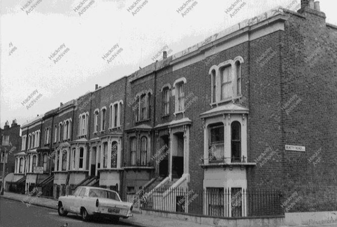
Then & Now: Beatty Rd looking north east. Compulsory Purchase Order was issued in the 70s for the houses where Yorkshire Grove Estate is now. The former Earl of Warwick pub is on the right, on the corner where Warwickshire Rd once was.
Paula Cannon: “My family was almost the last to move out of Shellgrove Road before demolition, and I have got the Shellgrove Road road sign that was on the wall right opposite our house.” - - Shellgrove Road Estate in south Stoke Newington was built in the 1980s.
Victorian Road with Gunstor Road on the right looking east near Nevill Road in 1972. Yorkshire Grove Estate was built on the site in the 1970s. This is the same view today. Courtesy of flickr.com/photos/seadipp… https://t.co/hh24lYVPcj
@Schopflin Nope. The large estates such as Woodberry Down Estate, Lordship South Estate, Yorkshire Grove Estate and Shellgrove Road Estate were the result of city planning. Bomb damage resulted in much smaller housing development in Defoe Road and Albion Road for example.
@drewerydyke At the same time you had the clearing of Victorian streets where Shellgrove Road Estate is now and also the clearing o houses to make way for Butterfield Green.
Victorian Road/Nevill Road before Yorkshire Grove Estate was built in the 1970s
Victorian Road/Nevill Road before Yorkshire Grove Estate was built in the 1970s. This view is looking south with Nevill Road on the right.
@realnickperry @EngineerLondon turns out there was another electricity sub-station in Stoke Newington adjoining 14 Victorian Road. It was removed when the area was cleared to develop the Yorkshire Grove Estate.
@Huriye Similar story as Yorkshire Grove Estate between Nevill Rd and Coronation Avenue and Shellgrove Road Estate between Crossway and Pellerin Rd. Also, Milton Gardens Estate. All were developed in the 60s and 70s on the site of Victorian streets. Butterfield Green another exa…
@Huriye Similar story as Yorkshire Grove Estate between Nevill Rd and Coronation Avenue and Shellgrove Road Estate between Crossway and Pellerin Rd. Also, Milton Gardens Estate. All were developed in the 60s and 70s on the site of Victorian streets. Butterfield Green another example.

Then & Now: Corner of Nevill Road/Victorian Road. The Prince Albert pub can be seen on the left. Yorkshire Grove Estate was developed in the 1970s. (More of my ‘Then & Now’ images: Slider: stokey.annaro.se Animated: stokenewingtonhistory.com/then-and-now-a…) https://t.co/gLjlRLyuL0

Then & Now: Victorian Fish Bar on the corner of Nevill Road/Victorian Road. Yorkshire Grove Estate was developed in the 1970s. (More of my ‘Then & Now’ images: Slider: stokey.annaro.se Animated: stokenewingtonhistory.com/then-and-now-a…) https://t.co/LkRGQ5m54y

Then & Now: Victorian Road looking west towards Nevill Road. The Prince Albert pub on the right. Yorkshire Grove Estate was developed in the 1970s. (More of my ‘Then & Now’ images: Slider: stokey.annaro.se Animated: stokenewingtonhistory.com/then-and-now-a… ) https://t.co/G1jNi98nnW
1971 - Land comprised in the Compulsory Purchase Order to develop the Yorkshire Grove Estate
@Britinfloridaus You can include the 70s as wholesale clearance was used to develop Yorkshire Grove Estate between Nevill Road and Victorian Grove and also Shellgrove Road Estate north of Crossway in south Stoke Newington
@RobinJarossi There was also significant clearing of Victorian streets in the 70s and early 80s to create Butterfield Green, Yorkshire Grove Estate and Shellgrove Estate in south Stoke Newington. Clearing of older houses (big and small) took place in the 1930s to build social ho…
@RobinJarossi There was also significant clearing of Victorian streets in the 70s and early 80s to create Butterfield Green, Yorkshire Grove Estate and Shellgrove Estate in south Stoke Newington. Clearing of older houses (big and small) took place in the 1930s to build social housing.
2a Warwickshire Road, Stoke Newington near Beatty Road in the 1910s and in 1974. The road was cleared and gone once the Yorkshire Grove Estate was built in the 1970s. All that’s left of it is a ‘ghost’ street sign on the former Earl of Warwick pub at 9 Beatty Road.
Hartopp Court in Nevill Road, part of the Yorkshire Grove Estate, is named after the Hartopp family and likely John Hartopp. x.com/AWatson47/stat…
Then & Now: Beatty Road. The Earl of Warwick pub on the right. It is now residential property. The houses were demolished in the 1970s as part of the development of Yorkshire Grove Estate.

Then & Now: Nevill Road/Victorian Road. Yorkshire Grove Estate was developed in the 1970s.

Then & Now: Nevill Road/Victorian Road. Yorkshire Grove Estate was developed in the 1970s.
Yorkshire Grove Estate was developed in the 70s on the site of houses that were occupied and demolished using Compulsory Purchase Orders. This included the Prince Albert pub. The former Earl of Warwick pub in Beatty Rd survived the denomination. It closed years later.
@SnakeJell @TheMumper You mean The Victoria, which was renamed Due South. The Prince Albert was down Victorian Road near Nevill Rd and was demolished in the 1970s when the surrounding streets were pulled down to make way for Yorkshire Grove Estate.
Terrific photos of one of Stoke Newington’s lost pubs. The Prince Albert was in Victorian Road near Nevill Rd and was demolished in the 1970s when the surrounding streets were pulled down to make way for Yorkshire Grove Estate. x.com/TheMumper/stat… https://t.co/eLipfSjV34
Then & Now: The Prince Albert pub, 32 Victorian Road near Nevill Road. A Courage brewery pub. The area was redeveloped in the 70s and Yorkshire Grove Estate was built on the site of streets that were cleared using Compulsory Purchase Orders.

Then & Now: West side of Gunstor Road. Pulled down in the 1970s when the area was cleared using CPOs to make way for Yorkshire Grove Estate.
Photos taken by Tony Hall at the long-gone Prince Albert pub at 32 Victorian Road close to Nevill Road. The area was redeveloped in the 70s and Yorkshire Grove Estate was built on the site of streets that were cleared using Compulsory Purchase Orders.
Then & Now: Nevill Rd/Victorian Rd (Photos by Tony Hall). The area was redeveloped in the 70s and Yorkshire Grove Estate was built on the site of streets that were cleared using Compulsory Purchase Orders.
Victorian Road, Stoke Newington in 1973. The area was redeveloped in the 70s and Yorkshire Grove Estate was built on the site.
Warwickshire Road - A surviving street sign (late 50s) of a ‘ghost’ street that no longer exists. It connected Beatty Rd and Victoria Rd and demolished when the area was redeveloped in the 70s to build Yorkshire Grove Estate. The sign is on the former Earl of Warwick pub.
@joeb_EY Here the WW2 bomb damage map and 1944 aerial. The immediate post-war housing development were the two blocks in Milton Grove and Shakespeare Walk and Milton Gardens Estate grew in the 60s-70s. @LynRennick is the expert on the history of that area in particular.
@joeb_EY @LynRennick This is 1971 showing how Milton Gardens Estate grew in the previous decade
Then & Now: Victorian Road (Now Victorian Grove, Yorkshire Grove Estate). The estate was built in the 70s.
@The_East_End Same spot today. The area was redeveloped in the mid 70s and Compulsory Purchase Orders were issued to clear the area to build Yorkshire Grove Estate.
Yorkshire Grove Estate was built in the 1970s on the site of mid 19th century houses that were demolished using Compulsory Purchase Orders. Also shops and one pub. Most of the houses that weren’t empty and in poor state, were likely considered ‘unsuitable for modern living’.
@janepetrie19 Yorkshire Grove was one of the original streets. The Yorkshire connection could be to the Walford Estate and original land owners of that area. @LynRennick might know.
1938 foundation stone on Hewling House in Matthias Road. One of several council housing developments by Stoke Newington Borough in the 30s. The Milton Gardens Estate it’s part of grew to include post-war housing in Milton Grove, Shakspeare Walk and additional blocks in the 1960s.
The Prince Albert pub, 32 Victorian Road near Nevill Road in 1967. Photos by Tony Hall. Note the bar partition on the right. The area was redeveloped in the 70s and Yorkshire Grove Estate was built on the site of streets that were cleared using Compulsory Purchase Orders.
I received confirmation from a person who used to go the Prince Albert, that this photo by Tony Hall in 1967 was also taken in the pub. The Prince Albert stood in 33 Victorian Rd near Nevill Rd. Demolished in the 70s along with many houses to develop Yorkshire Grove Estate
Then & Now: Victorian Road before the development of Yorkshire Grove Estate in the 1970s. The Prince Albert pub can be seen on the left. (Photo by Tony Hall)
Then & Now: Victorian Road before the development of Yorkshire Grove Estate in the 1970s. (Photo by Tony Hall)
John Stops (right) lived in Victoria Grove West behind Stoke Newington Police Station in the 1890s. The street was demolished in the 1970s as part of the development of Yorkshire Grove Estate. Photo courtesy of Peter Herring
@The_East_End Photo by Tony Hall. The shop, along with others and the Prince Albert pub nearby, were pulled down in the mid 70s when Yorkshire Grove Estate was built. Compulsory Purchase Orders were issued for dozens of houses in the area to clear the site.
Then & Now: Victorian Road (now Victorian Grove) corner of Nevill Road. The area was redeveloped in the 70s and Yorkshire Grove Estate was built on the site of streets that were cleared using Compulsory Purchase Orders.
Then & Now: Victorian Road (now Victorian Grove) in 1973. Gunstor Rd (right), Yorkshire Grove (left). The area was redeveloped in the 70s and Yorkshire Grove Estate was built on the site of streets that were cleared using Compulsory Purchase Orders.
Then & Now: Victorian Road (now Victorian Grove) in 1973. The Prince Albert pub on the right. The area was redeveloped in the 70s and Yorkshire Grove Estate was built on the site of streets that were cleared using Compulsory Purchase Orders.
Paula Cannon: “My family was almost the last to move out of Shellgrove Road before demolition, and I have got the Shellgrove Road road sign that was on the wall right opposite our house.” - - Shellgrove Road Estate in south Stoke Newington was built in the 1970s.
Then & Now: Victorian Road with Gunstor Road on the right looking east near Nevill Road in 1972. Yorkshire Grove Estate was built on the site in the 1970s. Courtesy of flickr.com/photos/seadipp… https://t.co/meIWz7k87b
Then & Now: Victorian Road (now Victorian Grove) corner of Nevill Road. The area was redeveloped in the 70s and Yorkshire Grove Estate was built on the site of streets that were cleared using Compulsory Purchase Orders.
The Prince Albert pub in the 1960s. Photos by Tony Hall. It was in Victorian Road near Nevill Rd, which is seen in the background. The pub was demolished in the 1970s when Yorkshire Grove Estate was built on the site of the Victorian houses and shops.
Then & Now: Victorian Road (now Victorian Grove) in 1973. The Prince Albert pub on the right. The area was redeveloped in the 70s and Yorkshire Grove Estate was built on the site of streets that were cleared using Compulsory Purchase Orders.
Then & Now: The Prince Albert pub, 32 Victorian Road near Nevill Road in 1967. Photo by Tony Hall. The area was redeveloped in the 70s and Yorkshire Grove Estate was built on the site of streets that were cleared using Compulsory Purchase Orders.
Then & Now: Victorian Road (now Victorian Grove) corner of Nevill Road. The area was redeveloped in the 70s and Yorkshire Grove Estate was built on the site of streets that were cleared using Compulsory Purchase Orders.
@MunicipalDreams The only council housing built by Stoke Newington Borough Council in the 1930s as far as I can recall, were Lordship South Estate in Lordship Terrace and Milton Gardens Estate in Matthias Road.
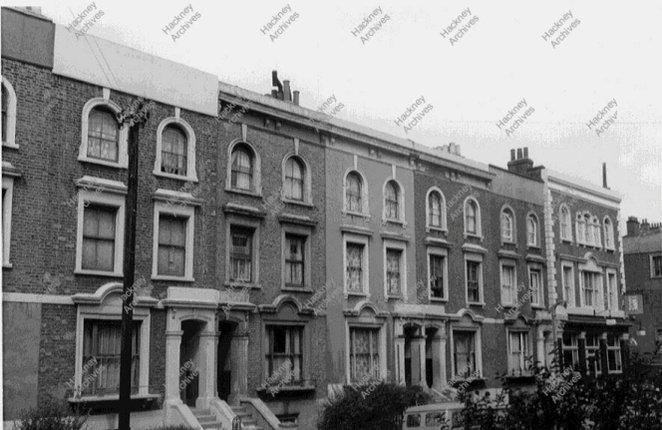
Then & Now: Gunstor Rd looking north with Beatty Rd on the right. The Victorian houses were demolished in the 1970s along with many others in the nearby streets for the development of Yorkshire Grove Estate.
These kind of urban redevelopment projects were fairly common in Stoke Newington in the 1970s, as Victorian houses, often occupied and in decent conditions were demolished to build modern housing or open spaces: Yorkshire Grove Estate, Shellgrove Rd Estate, Butterfield Green. ht…
These kind of urban redevelopment projects were fairly common in Stoke Newington in the 1970s, as Victorian houses, often occupied and in decent conditions were demolished to build modern housing or open spaces: Yorkshire Grove Estate, Shellgrove Rd Estate, Butterfield Green. x.com/HistoryOfStoke…
The Prince Albert pub in Victorian Road close to Nevill Road in the 1960s. It was demolished in the 1970s along with many houses in the surrounding streets to build Yorkshire Grove Estate. Photo by Tony Hall.
1904 ad - Jacob’s “Ideal” Sanitary Laundry in 107 Church St (Church St Supermarket today) and 43 Victoria Rd. The shops in Victoria Rd close to Nevill Rd were demolished in the 70s as part of the development of Yorkshire Grove Estate.
Aerial view in 1971 of the streets that were built in the 1850s as the Albert Town development. By 1971, it was a mix of Victorian, post-war and 1960s housing. Most of the Victorian houses, about 120, were demolished to create Butterfield Green in the late 70s-early 80s.
Contrary to common belief, large housing estates in Stoke Newington such as Milton Gardens Estate and Woodberry Down Estate, are the result of urban redevelopment rather than post-war rebuild on bomb sites. In 1952, most of the site of Milton Gardens Estate was still Victorian.
@LAnderson_Frank Yes. Large scale demolition of streets in Stoke Newington in the 70s was for the development of modern housing estates like Yorkshire Grove Estate for example. I’d love to uncover the council minutes and docs about the Butterfield Green development.
The only other housing built before WW2 by Stoke Newington Council was Lordship South Estate (7 blocks) 1934-6 and Milton Gardens Estate (3 blocks) 1938. Then latter was extended considerably in the 60s-70s to cover the entire area south of Butterfield Green. https://t.co/7O22Hp…
The only other housing built before WW2 by Stoke Newington Council was Lordship South Estate (7 blocks) 1934-6 and Milton Gardens Estate (3 blocks) 1938. Then latter was extended considerably in the 60s-70s to cover the entire area south of Butterfield Green. x.com/HistoryOfStoke…
Then & Now: Victorian Road/Nevill Road before the development of Yorkshire Grove Estate in the 1970s. (Photos by Tony Hall)
Surviving old sign of the Cowper Rd Estate, which today is part of Milton Gardens Estate. Built in the 1970s on the site of Victorian houses from the 1850s in Cowper Rd, Spenser Grove and Howard Road. One of several 70s housing estates in Stoke Newington. maps.app.goo.gl/qovYMo2X8f8P6z……
Surviving old sign of the Cowper Rd Estate, which today is part of Milton Gardens Estate. Built in the 1970s on the site of Victorian houses from the 1850s in Cowper Rd, Spenser Grove and Howard Road. One of several 70s housing estates in Stoke Newington. maps.app.goo.gl/qovYMo2X8f8P6z… https://t.co/RoyB1166qR
Then & Now: Victorian Road (now Victorian Grove) corner of Nevill Road. The area was redeveloped in the 70s and Yorkshire Grove Estate was built on the site of streets that were cleared using Compulsory Purchase Orders.
Then & Now: Victorian Road (now Victorian Grove) in 1973. The Prince Albert pub on the right. The area was redeveloped in the 70s and Yorkshire Grove Estate was built on the site of streets that were cleared using Compulsory Purchase Orders.
Then & Now: Victorian Road (now Victorian Grove) in 1973. Gunstor Rd (right), Yorkshire Grove (left). The area was redeveloped in the 70s and Yorkshire Grove Estate was built on the site of streets that were cleared using Compulsory Purchase Orders.
Contrary to common belief, large scale housing estates like Lordship South Estate (1930s), Shellgrove Road Estate (1970s) and Yorkshire Grove Estate (1970s) were built as urban redevelopment schemes, not on WW2 bomb sites. Local bomb sites were often much smaller in comparison.
Orpen Road looking south towards Beatty Road in 1966. The street was demolished in the 1970s when the area was redeveloped and Yorkshire Grove Estate was built on the site of several streets that were demolished using Compulsory Purchase Orders by the council.
This was the view from Knebworth Rd at the corner of Nevill Rd and Victorian Road (now Victorian Grove). The area was redeveloped in the 70s with many Victorian houses, shops and a pub demolished to make way for Yorkshire Grove Estate. x.com/The_East_End/s…
@IanPethick I don’t know which ones in particular the council had in mind but I’d guess Albert Town where Milton Gardens Estate and Butterfield Green are now, and possibly the site that was also cleared in the 1970s for Yorkshire Grove Estate.
@IanPethick The houses where Milton Gardens Estate and Yorkshire Grove Estate are now, were built in the 1850s-60's so lacked mod cons, and even by the 1930s some were likely in need of repair, had no hot water, no indoor toilet or bath, aging/poor plumping and electric wiring e…
@IanPethick The houses where Milton Gardens Estate and Yorkshire Grove Estate are now, were built in the 1850s-60's so lacked mod cons, and even by the 1930s some were likely in need of repair, had no hot water, no indoor toilet or bath, aging/poor plumping and electric wiring etc.
@LAnderson_Frank @Vincent52290499 @realnickperry @walk_hackney 1971 vs 1989. The majority of the houses were occupied when compulsory purchase orders were issued by the council in the late 70s. Cowper Rd Estate was developed prior to that in parts of Cowper Rd, Spenser Grove and…
@LAnderson_Frank @Vincent52290499 @realnickperry @walk_hackney 1971 vs 1989. The majority of the houses were occupied when compulsory purchase orders were issued by the council in the late 70s. Cowper Rd Estate was developed prior to that in parts of Cowper Rd, Spenser Grove and Howard Rd (now part of Milton Gardens Estate).
@realnickperry @LAnderson_Frank @Vincent52290499 @walk_hackney Yes. That’s why it’s surprising the land was dedicated to the creation of a small park than housing as was the case elsewhere in Stoke Newington e.g. Yorkshire Grove Estate, Cowper Rd Estate and Shellgrove Road Estat…
@realnickperry @LAnderson_Frank @Vincent52290499 @walk_hackney Yes. That’s why it’s surprising the land was dedicated to the creation of a small park than housing as was the case elsewhere in Stoke Newington e.g. Yorkshire Grove Estate, Cowper Rd Estate and Shellgrove Road Estate in the 1970s.
Milton Gardens Estate spans 37 years, merging smaller estates, with the bulk from the 1960s-70s. Just 2 blocks emerged from a bomb site. The two oldest blocks are from 1938. Initially, it was Albert Town, a 1850s development built by the National Freehold Land Society.
Albert Town (Allen Rd, Milton Grove, Shakspeare Walk, Spenser Grove, Cowper Rd, Howard Rd, Wordsworth Rd) was developed in the 1850s by the National Freehold Land Society, which sought to acquire land and divide it into plots of a size that would entitle the owner to a vote. App…
Albert Town (Allen Rd, Milton Grove, Shakspeare Walk, Spenser Grove, Cowper Rd, Howard Rd, Wordsworth Rd) was developed in the 1850s by the National Freehold Land Society, which sought to acquire land and divide it into plots of a size that would entitle the owner to a vote. Approximately 620 houses were built, of which 28% survive today. The majority of the remaining 72% were demolished in the 1950s-1970s to make way for new housing blocks, which later became part of Milton Gardens Estate. Around 120 were demolished in the late 1970s to make way or a new public park. A relatively small number of the original houses sustained significant bomb damage and 2 housing blocks were built on their site in the late 1940s in Milton Grove (Binyon House) and Shakspeare Walk (Shelley House). (All the houses in the photos were demolished in the 1970s) Built vs. surviving Victorian housing in the former Albert Town: Allen Road 77/70
Milton Grove 130/60
Shakspeare Walk 141/46
Spenser Grove 102/0
Cowper Road 78/0
Wordsworth Road 15/0
Howard Road 88/0
@LAnderson_Frank It’s mainly Milton Gardens Estate which grew gradually and amalgamated smaller housing schemes over the years.
The County of London Plan 1943 stated that the required public open space in a Metropolitan Borough should be 4 acres per 1,000 people. This meant Stoke Newington, with a population of 50,000, needed to have 200 acres of public open space (the whole borough was just 864 acres).…
The County of London Plan 1943 stated that the required public open space in a Metropolitan Borough should be 4 acres per 1,000 people. This meant Stoke Newington, with a population of 50,000, needed to have 200 acres of public open space (the whole borough was just 864 acres). With Clissold Park (57 acres) being the only public space, Stoke Newington was 'missing' 143(!) acres of public open space. The proposal outlined in the plan, which the Stoke Newington Council acknowledged, was to extend Clissold Park to Lordship Park and link it to Abney Park and Highbury Fields. That plan never materialised. I was curious to know where do we stand 81 years later. Here's the breakdown of all the public open spaces, large and small, in the former Borough of Stoke Newington. We're still 90 acres short! Clissold Park: 57 acres Butterfield Green: 5.9 acres
Allens Gardens: 2.17 acres
Abney Park: 31 acres
Quaker Burial Garden: 0.24 acres
Yorkshire Grove Play space: 0.49 acres
West Reservoir (to open in the future): 3.65 acres
New River Path + Playarea (West reservoir) 2.94 acres
Woodberry wetlands: 5.53 acres
New River Path (East reservoir): 1.38 acres Total: 110.3
@mamacaskill It was 18 Shellgrove Road and looks like a factory building, thought it was small. This 1952 map. 20 years after the photo was taken more or less. I checked the 1894 map and it’s the same building then.
Two new mashups showing Crossway in 1966 before Shellgrove Road Estate was built in the 1970s. Originally named Castle Street, Crossway was the southern boundary of the parish, and later Metropolitan Borough of Stoke Newington. The north side was in Stoke Newington and south sid…
Two new mashups showing Crossway in 1966 before Shellgrove Road Estate was built in the 1970s. Originally named Castle Street, Crossway was the southern boundary of the parish, and later Metropolitan Borough of Stoke Newington. The north side was in Stoke Newington and south side in Hackney. (Find out more about my 'Then & Now' projects here: stokenewingtonhistory.com/then-now/)