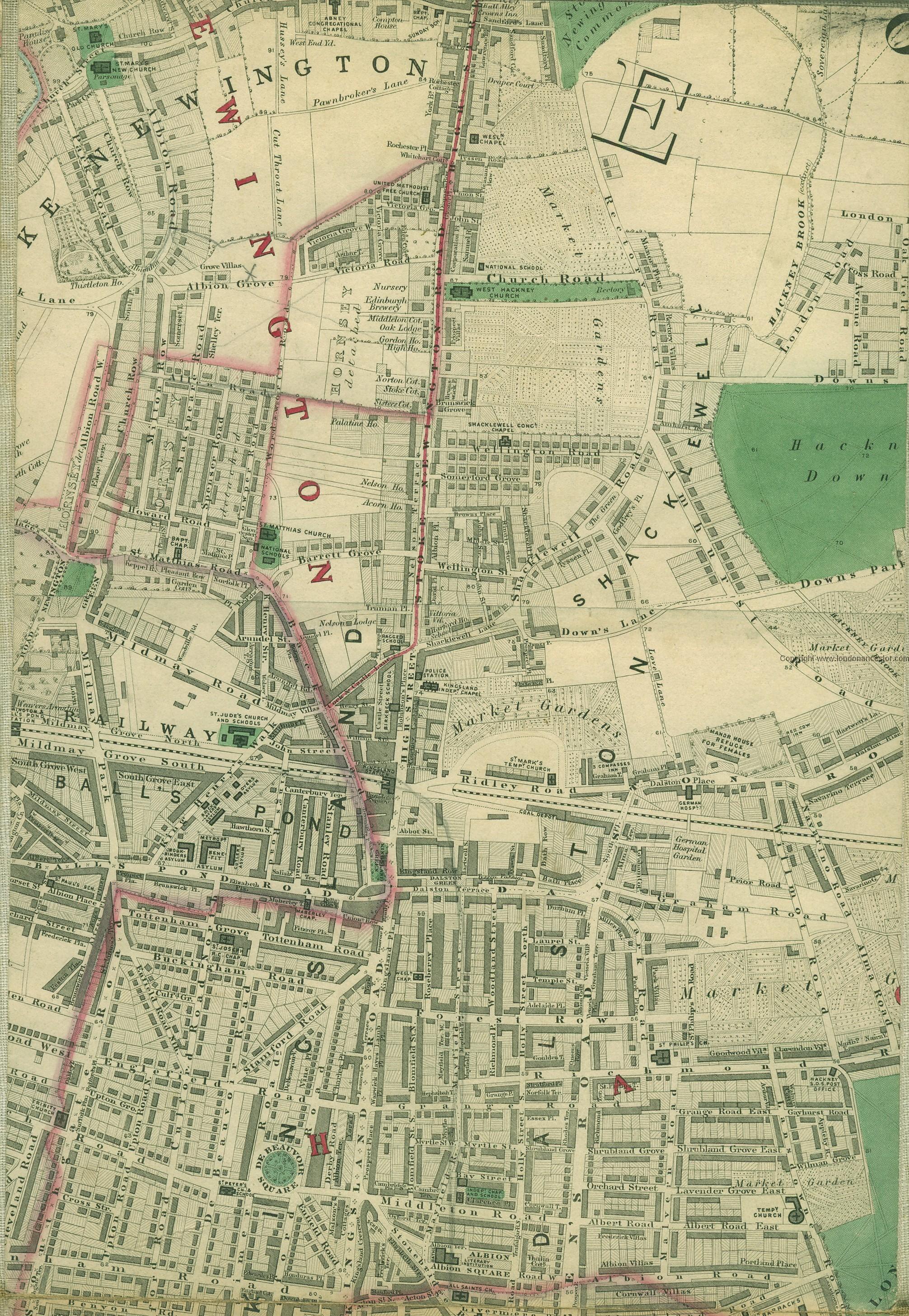
A map of Stoke Newington - 1862. 27 roads were renamed in 1937 to avoid confusion with others in London mappalondon.com/london/north-e…
Back to themes
Maps
Visual Records
Historic maps, plans, directories with maps, and cartographic records.
917 (3%) posts currently match this theme.
Note: Theme classification is AI-enabled and imperfect, so some posts here will be misclassified and some relevant posts may be missing.
Filter posts within this theme by keyword, date range, image presence, or sort order.
Show theme trend over time Hide theme trend
Theme trend
Matches over time
Showing all years in this theme.
Showing first 100 posts…
RT @islingtongztte: Bar has ‘put Stoke Newington on the map’ by earning place in prestigious Zagat guide islingtongazette.co.uk/news/health_2_4371…
You can get these old ordnance survey maps of Stoke Newington (1868, 1894, 1914) in @StokeyBookshop. A real treat.
RT @jsomerfield: @HistoryOfStokey Highly detailed Victorian maps of London goo.gl/iT53cJ (including Stokey! - http://t.co/nyAukIgC…
@thisismikehall can't imagine another building with a spire. Off to the maps!
Stoke Newington Google map in 1814
@TJAWheeler Here's the link to the map: mappalondon.com/london/north-e…
Stoke Newington 1868 Ordnance Survey Map 2.bp.blogspot.com/-3EuaeoY5hTU/T…
Plan of an 18th-century house on Church Street called Manor House. It was replaced in 1866 by seven houses and shops.
1875 Plan of Newington Hall, which stood at the corner of Church St/Green Lanes. Replaced 1876-7 with Statham Grove.
Sale plan of The Willows (later called Kennaway Hall), a house close to Church St/Green Lanes. Demolished c. 1953.
A map of Stoke Newington Church Street c. 1848 british-history.ac.uk/image.aspx?com…
Stanford’s Library Map Of London And Its Suburbs 1864 (Click, scroll and click again for hi-res view) london1864.com/stanford22.htm
Green Lanes appears on the first map of Stoke Newington from 1577.
@PaulieTandoori A map of the bombed areas show bombs hit every corner of the borough, including the two churches on Church St
1846 map of Stoke Newington 2.bp.blogspot.com/-XzT3H0P1Iiw/T…
Booth Poverty Map of Stoke Newington, 1898. 1.bp.blogspot.com/-cnoHitPR8LQ/Ta8uTialVJ… RED: Middle class. Well-to-do. YELLOW: Upper-middle and Upper classes
Map of the paths and grave sections within Abney Park Cemetery upload.wikimedia.org/wikipedia/comm…
1922 map showing the New River flowing along Church St towards Canonbury. It terminated by the park gates from 1946. hipkiss.org/data/maps/bartholomews-pocket…
Hi-Res Stoke Newington war damage map 1939-45 flickr.com/photos/alandenney/11728746906/… (via Alan Denney flickr.com/photos/alandenney/11728746906/…)
RE war damage map - Black -Total destruction, Purple - Damaged beyond repair, Dark Red - Doubtful if repairable
RE war damage map (Cont.) - Light Red - Seriously damaged, but repairable at cost, Orange - General blast damage, not structural.
RE war damage map (Cont.) - Yellow - Blast damage, minor in nature, Large circle - V1 flying bomb. Small circle o - V2 rocket.
A two-part garden plan of Shirley Hibberd's garden at Lordship Terrace, Stoke Newington c. 1858
A map of Stoke Newington 200 years ago british-history.ac.uk/image.aspx?com…
A map of Stoke Newington Common from 1761. Historically, the Common was used for pasture throughout the year. clubplan.org/CMS/usr/1517/i…
Map of Stoke Newington Common and east side of Stoke Newington High Street c. 1830
The exact site of Abney House can be seen in this map of Abney Park Cemetery upload.wikimedia.org/wikipedia/comm…
A map of Stoke Newington from 1828
1936 - Map of Stoke Newington (South west)
@realnickperry @HackneySociety Thistleton House appears in the map used as my background image if that helps.
@cathjdean same answer applies I'm afraid. I have only seen the location of the a Clissold swimming baths in old maps.
A map showing the location of the Clissold Road Swimming Baths, which were demolished in 1997.
82(!) past and present pubs and bars in Stoke Newington pubology.co.uk/maps/n16.html
1914 map showing the Biograph cinema next to the 3 Crowns and Whincop & Son timber yard where Wilmer Place is today
1734 - The first official map of Stoke Newington. It was commissioned by the Lady of the Manor, Mary Abney flickr.com/photos/1240350…
1824 - Map of Stoke Newington flickr.com/photos/1240350…
A map of the 31 May/1 June 1915 raid on London which hit Stoke Newington books.google.co.uk/books?id=JySSF…
A 1964 map of Stoke Newington showing the Clissold Park bandstand and the New River still running along Church Street
A map of Stoke Newington in the mid 17th century
1888 map - Clissold Park is a privately owned estate called Newington Park. Bought for the public for £96K in 1889.
1846 map of Stoke Newington 2.bp.blogspot.com/-XzT3H0P1Iiw/T…
Map of Stoke Newington - 1862
A map from 1915 showing Daniel Defoe school on Oldfield Road. Later converted to flats (Scholars Place).
@VictorianLondon A map of the area perhaps? That photo by Alan Dennay is from the late 1970's. His fantastic photos: flickr.com/photos/alanden…
1814 - A map of Stoke Newington; a rural village with two rivers, two streets surrounded by fields and meadows.
A map from 1864 showing the location of The Willows estate in Paradise Row, Stoke Newington. Notice the two bridges.
1913 map showing original path of the New River and Church St before it was renamed Stoke Newington Church St (1937)
1930 - Map of Stoke Newington. Download original size (6257 x 4834) from: farm3.staticflickr.com/2914/144826512… http://t.co/Pab6EQ210n
1928 Tramways pocket map, Stoke Newington
I’m intrigued by this large ‘Tank’ in a map from 1868 where the entrance to Clissold Park on Church St is today
@VictorianLondon it was quite large. I'll check later maps to see if it was still there once the park opened.
@clissoldpeople the map places it right along Church St where the entrance opposite the new church is, so playground location isn't it.
1814 Map of Stoke Newington flickr.com/photos/british…
1906 Map showing the boundaries of the Metropolitan Borough of Stoke Newington (1899-1965).
c1920 - Map of Stoke Newington. 27 streets were renamed in 1937. Example: Park St renamed Yoakley Rd.
1920’s map shows Barn St connecting Church St and Lordship Terrace, Clisssold Crescent called Park Lane
@yellowhawk59 @TypeTasting Why don’t you visit the rest of Stoke Newington Church St? :) @51.56143,-0.082064,3a,75y,276.79h,83.91t/data=!3m4!1e1!3m2!1snm5TfmWu5juRLIVq-wEKig!2e0!6m1!1e1">google.co.uk/maps/@51.56143…
1814 map showing the gardens of 171,173 were in fact relatively smaller than the ones in the affluent parts of SN
Plan of a Stoke Newington town house known as the Manor House, which stood on the corner of Church St/Bouverie Rd.
1892 map - Stoke Newington part of the constituency of Hackney North. Stoke Newington was a constituency: 1918-1950.
@cmccrudden @VictorianLondon It is related for that reason though on the map you see it’s was the Clapton end of the street.
@duncr @VictorianLondon The map charts its path as further east towards Clapton, though it may not be accurate of course.
1938 - Map of Stoke Newington. Note the New River along Church St. It was renamed Stoke Newington Church St in 1937
1933 - Map of Stoke Newington. 27 streets were renamed 4 years later to avoid confusion with other London streets
1948 - Map of Stoke Newington. 474 houses were hit during WW2 and four grand churches damaged beyond repair
@Huriye I’m afraid I’m not familiar with a Mansion House on Albion Road. Can you include a street map pic? Might jog my memory :)
1904 map of Stoke Newington. Abney Congregational Church is opposite Church St entrance to the cemetery. It was…
The 1904 map also shows the Quaker meeting house and burial ground in Park Street. The street was renamed Yoakley Road in 1937.
1904 map showing the mansions of Paradise Row (later part of Church St) opposite Clissold Park and the New River
@HackneyKnits I’ll have a look at Victorian and Edwardian ordnance survey maps I have to see when it appeared.
Not Stoke Newington but still great work by @VictorianLondon mapping old NE postcode street signs (1858-66) google.com/maps/d/edit?mi…
1848 map of Stoke Newington
1954 map of Stoke Newington. Note Aldam Place cottages and Whincop & Son's timber yard where Wilmer Place is today.
1927 map of Stoke Newington. Note the New River along Church St and Abney Congregational Church opposite cemetery
Mid 19th century map of South Stoke Newington and Dalston mappalondon.com/london/north-e…
1874 map of Stoke Newington by Edward Stanford themaphouse.com/Zoom.aspx?id=1…
c.1890 Charles Booth’s colour coded social profiling map including Stoke Newington themaphouse.com/Zoom.aspx?id=1…
1892 map of Stoke Newington by George Philip & Son themaphouse.com/Zoom.aspx?id=1…
Charles Booth’s c.1890 map shows ‘Yellow’ (Upper-middle, Upper classes. Wealthy) Paradise Row, Park Cres. &Church Row
Charles Booth’s c.1890 map shows ‘Light blue’ (Poor) Barn St. It was 1 of 7 slum clearance areas in 1934.
Charles Booth’s c.1890 map shows ‘Red’ (Midl class. Well-to-do.) Church St. West end is ‘Yellow’(Uppr-midl, Uppr cls)
Daniel Defoe’s estate on Church St, Stoke Newington marked on today’s map. It was demolished in 1868.
This handy map produced by @LynRennick shows how Newington Green is divided between Stoke Newington and Islington
@padster have a look at bombsight.org/#15/51.5050/-0… I'll try and find another map I know
Explore Stoke Newington's socio-economic profile in 1899 using Charles Booth's poverty map (enter a post code) booth.lse.ac.uk/cgi-bin/do.pl?…
.@bowesmanor map of Stoke Newington WW2 bomb damage
1932 map showing the New River running along the historically affluent Paradise Row (western Church St opposite prk)
A couple of 1914 maps at @StokeyBookshop.Explore 27 streets that were renamed in 1937 (including Church Street).
Sale plan of the Manor House at Church St/Bouverie Rd. Typical grand house on Church Street till the 1870s.
Map of Stoke Newington in 1814. Rapid development around Church Street began in the 1870s. Albion Rd in the 1830s.
Map showing the location of Paradise Bridge and Park Lane Bridge near the junction of Church St/Clissold Crescent
This is terrific: Zoom into Stoke Newington then slide the bar (top left) to see what it was like in the 1890’s. maps.google.com/gallery/detail…
c. 1895 map - Now and Then - Church Street and Aldam Place before the creation of Wilmer Place
c. 1895 map - Church St was widened on 3 occasions. See how 81-93 Church St had their front gardens truncated
c. 1895 map - Barn Street used to connect Church Street and Lordship Terrace (formerly Meadow St)
c. 1895 map - Fairy St, Bowling Green St, Union St, Clevedon St and Bull Alley: Gone when Smalley Estate was built.
c. 1895 map also allows you to explore 27 Stoke Newington street names that were changed in 1937 (Incl. Church St) google.com/maps/d/u/0/vie…
1894 map showing the Rose & Crown (P.H) in its original location opposite current one before the junction was widened
1894 map showing the 4 houses called Glebe Place with their extensive gardens. Replaced later with blocks of flats.