In the 1740s buildings stretched from Church Street northward half-way to Hackney brook and southward to Cut Throat Lane
Back to themes
Hackney Brook
Green Space and Waterways
Hackney Brook, its course, culverting, and traces in the landscape.
113 (<1%) posts currently match this theme.
Note: Theme classification is AI-enabled and imperfect, so some posts here will be misclassified and some relevant posts may be missing.
Filter posts within this theme by keyword, date range, image presence, or sort order.
Show theme trend over time Hide theme trend
Theme trend
Matches over time
Showing all years in this theme.
Showing first 100 posts…
@globemakers There was also Hackney Brook through Abney Park and the Common. Now only the name Brook Road remains. en.wikipedia.org/wiki/Hackney_B…
From 1799 and at least until 1845 Northwold Rd was called Kate’s Lane. For a short period it was later called Brook St, after Hackney Brook
SN Common was originally bounded on the north side by Hackney Brook and was used for grazing livestock until the nineteenth century
Bridges were required for Hackney brook, which could flood to a width of 70 ft. including as far upstream as Stoke Newington High Street.
The Hackney Brook which ran through Abney Park and Stoke Newington Common was submerged and culverted as a sewer in 1860.
@TheoJThomas Would you happen to have any material, visual or otherwise, concerning the Hackney Brook you could share?
The course of the Hackney Brook through Stoke Newington (it was submerged and culverted as a sewer in 1860). highburywildlifegarden.org.uk/wp-content/upl…
Stanford Bridge over the Hackney Brook was located on the High Street near the present cemetery gates
Before Stanford Bridge there was a ford, Sanford (the sandy ford) where the High Street crossed the Hackney Brook
A wooden Stanford Bridge, which existed by 1675 was replaced by a two-arched brick bridge in 1826. The Brook was culverted over in the 1850s
Bridges in Stoke Newington included: Paradise Bridge and Park Lane Bridge (New River) and Stanford Bridge (Hackney Brook)
Abney Park included two elm walks to the island Heronry of the Hackney Brook: Great Elm Walk and Little Elm Walk.
In the late 1790's Jonathan Hoare diverted the polluted Hackney Brook away from his new home, which was later renamed Clissold House.
@Gooner_AK And the Hackney Brook and Stamford Bridge were still around
The Hackney Brook crossed the High St at the junction with Cazenove Rd.
@clearmapping both the New River and Hackney Brook are clearly visible and labelled
The 'Brook Cottage' pillar at 6 Northwold Rd is a relic of a villa, which stood on this site by the Hackney Brook
The course of the Hackney Brook through Stoke Newington. Stamford Bridge over the river was opposite the cemetery. highburywildlifegarden.org.uk/wp-content/upl…
RT @VictorianLondon: Here's Stoke Newington in the 1840s, the Hackney Brook still visible
@cmccrudden @VictorianLondon This surviving pillar on Northwold Rd is of a villa next to the brook flickr.com/photos/4612301…
@VictorianLondon @cmccrudden The Clissold Park lakes, the last surviving part of the brook still lablled accordingly
@VictorianLondon @cmccrudden I hope one day to find a drawing of Stamford Bridge on SN High St where it crossed the brook opposite cemetery.
The path of the Hackney Brook through Stoke Newington. Note Stamford Bridge opposite main cemetery entrance.
Beckmere and Runtzmere lakes in Clissold Park still referred to on Google Maps as Hackney Brook. It ran along the northern edge of the park
Lost bridges of SN: Park Lane Bridge (Clissold Crescent) & Paradise Bridge (Church St): New River, Stamford Bridge (High St): Hackney Brook
"Those toilets used to get flooded from the underground stream"(Mandy Ward). Probably Hackney Brook. Photo: A. Denney
"With Hackney Brook now redirected underground there is little to remind the residents of Stoke Newington that a 30-foot-wide stream..." 1/2
@TheFoxReformed @realnickperry @Schopflin Something to do with the Hackney Brook running underground?
@TheFoxReformed @realnickperry @Schopflin The Hackney Brook was 9 meters wide at its widest point. Must have quite a sight.. and smell..
@losturbanrivers Hi. Have you ever come across drawings of the Hackney Brook by any chance? Or of Stamford Bridge in Stoke Newington? Thanks
The lost rivers that lie beneath London (the Hackney Brook that runs through Stoke Newington can be seen on the map) bbc.co.uk/news/uk-englan…
@MickMcAteer straight from the Hackney Brook!
The course of the Hackney Brook through SN. Culverted 1860. Stamford Bridge over it was near High St/Northwold Rd.
@lucyinglis @lukegreen71 @VictorianLondon “…an inn beyond the brook, the Weaver's Arms, licensed by 1750” british-history.ac.uk/vch/middx/vol1…
1855 map showing the Hackney Brook running through Stoke Newington. It was culverted in 1860. locallocalhistory.co.uk/gsn/images/map…
@realnickperry @CaIIumDVS I heard that it was routinely flooded by the Hackney Brook which was culverted in 1860 and ran very near to it.
@realnickperry @andrewellson secret entrance to the culverted Hackney Brook hopefully??
@realnickperry @VictorianLondon @andrewellson @EngineerLondon It's on the Hackney Brook path as far as I can tell. Brook Cottage very close
This pillar on Northwold Rd is the sole relic of a villa which stood on the bank of the Hackney Brook.
This map also provides a good view of the course of the New River and Hackney Brook through Stoke Newington x.com/historyofstoke…
1741 map of the small rural village of Stoke Newington. Note the courses of the New River and Hackney Brook.
The closest we'll ever to get to see what the Hackney Brook which roughly ran at this a spot looked like before it was culverted in 1860 x.com/paulwood1961/s…
The course of the Hackney Brook through Stoke Newington till it was culverted in 1860
In the late 1790's Jonathan Hoare diverted the polluted Hackney Brook away from his new home, which was later renamed Clissold House.
@ms_peaceweaver Good question. I heard it used to get flooded by the Hackney Brook no and then when it was still active.
@ConorMuller Yep. Google maps still refers to the ponds in Clissold Park as Hackney Brook even though it hasn't run there since 1860!
The Hackney Brook ran through Stoke Newington with Stamford Bridge on the High St opposite the cemetery. It was culverted in 1860.
@losturbanrivers hi. Have you looked into the Hackney Brook or New River? Thanks.
@ghostsigns note Hurtsleigh’s Bread in the Brook Road photo. Same as one on Church St/Fleetwood St?
The Hackney Brook, which ran along Abney Park Cemetery can be seen on the map. Culverted in 1860. Stamford Bridge was on the High Street. x.com/HistoryOfStoke…
@LynRennick What do you mean by ‘pic of the Hackney Brook’
RT @LynRennick: @HistoryOfStokey The Hackney Brook used to flow down Mountgrove Road and there was a bridge just beside the Arsenal Tavern.…
@highamnews any references to the New River in SN that you can think of? Grazebrook Rd and Brooke Road for example named after the Hackney Brook.
4 facts about @AbneyParkN16: 1) 1st designated Local Nature Reserve in Hackney 2) Hackney’s 5th largest public open space 3) The Hackney Brook which ran along its northern boundary was culverted as a sewer in 1860 4) 1,500 people gathered for the opening ceremony on 20.5.1840
1741 map showing the small rural village of Stoke Newington. Note Newington Bridge on Church St, it was later renamed Paradise Bridge. Stamford Bridge over the Hackney Brook was where the cemetery entrance on the High St is now. Lordship Road was originally called Lordship Lane.
‘Isaac Watt’s Mound’ in Abney Park Cemetery was on the bank of the Hackney Brook when it was simply Abney Park; the vast grounds of Abney House in the early-mid 18th century. Watts (en.wikipedia.org/wiki/Isaac_Watts) was a life-long houseguest of the Abney family. https://t.co/pqlCNTpqOn
1790 map showing the small rural village of Stoke Newington, which was limited to Church St and the junction with the High St. Note the course of the New River and also the Hackney Brook. Both ran through the village.
A pillar on Northwold Road with the writing ‘Brook Cottage’ is all that remains of a house that once stood on the bank of the Hackney Brook, where West Hackney Almshouses are now. The Hackney Brook, which ran across Stoke Newington was culverted in 1860.
The ‘Brook Cottage’ pillar, which is now part West Hackney House in Northwold Road is different from all the other pillars. That’s because it’s a remnant of a detached villa called Brook Cottage, which stood by the south bank of the Hackney Brook. The brook was culverted in 1860
The Hackney Brook ran through Stoke Newington till it was culverted in 1860. Grazebrook Road and Brooke Road denote its course, as well as a pillar with Brook Villa in Northwold Rd. A bridge in the High St over the Hackney Brook opposite the cemetery was called Stamford Bridge.…
The Hackney Brook ran through Stoke Newington till it was culverted in 1860. Grazebrook Road and Brooke Road denote its course, as well as a pillar with Brook Villa in Northwold Rd. A bridge in the High St over the Hackney Brook opposite the cemetery was called Stamford Bridge. x.com/LDN/status/102…
The path of the Hackney Brook can be traced through street names such as Grazebrook Road and Brooke Road for example. x.com/HistoryOfStoke…
The course of the Hackney Brook which ran through Stoke Newington and was covered up in 1860. Notes by the late Stoke Newington historian Derek Baker (You can read my obituary for Derek here: stokenewingtonhistory.com/derek-baker-193…) https://t.co/Ojj3Csq5Jt
Pleased to announce that Laurie Elks will talk about the Hackney Brook as part of the upcoming 10th Stoke Newington History Talks in late May-early June. The Hackney Brook ran across Stoke Newington and was culverted in 1860. Event mailing list: twitter.us15.list-manage.com/subscribe?u=… https://t…
Pleased to announce that Laurie Elks will talk about the Hackney Brook as part of the upcoming 10th Stoke Newington History Talks in late May-early June. The Hackney Brook ran across Stoke Newington and was culverted in 1860. Event mailing list: twitter.us15.list-manage.com/subscribe?u=… https://t.co/iRArfJIexP
@Flora150Project No. The New River. The Hackney Brook was culverted in 1860. It went under the High Street opposite Northwold Road. It was called Stamford Bridge.
TICKETS NOW AVAILABLE for the 10th Stoke Newington History Talks event 3 talks: Local history treasure troves, Hackney Brook and the Willows estate May 20th, 19:30 in @stmatthiashalls, Wordsworth Road N16 8DD Book your tickets here: eventbrite.com/e/stoke-newington-history-… https://t.co/GEHtJltfC1
The Hackney Brook was a significant feature of Stoke Newington’s landscape till 1860. On 20.5.19 as part of the 10th SN History Talks event, Laurie Elks will describe the river that both Grazebrook Rd and Brooke Road are named after. BOOK YOUR TICKETS: eventbrite.com/e/stoke-newing… ht…
The Hackney Brook was a significant feature of Stoke Newington’s landscape till 1860. On 20.5.19 as part of the 10th SN History Talks event, Laurie Elks will describe the river that both Grazebrook Rd and Brooke Road are named after. BOOK YOUR TICKETS: eventbrite.com/e/stoke-newing… https://t.co/xLYRBaPZnV
A few tickets are still available for the 10th Stoke Newington History Talks event on May 20th, 19:30 in @stmatthiashalls, Wordsworth Road N16 8DD 3 talks: Local history treasure troves, Hackney Brook and the Willows estate Book your tickets here: eventbrite.com/e/stoke-newington-history-… https:/…
A few tickets are still available for the 10th Stoke Newington History Talks event on May 20th, 19:30 in @stmatthiashalls, Wordsworth Road N16 8DD 3 talks: Local history treasure troves, Hackney Brook and the Willows estate Book your tickets here: eventbrite.com/e/stoke-newington-history-… https://t.co/CmYlu5ncXW
Thanks to the 100 people who came to the 10th Stoke Newington History Talks event this evening in @stmatthiashalls. Great talks by Laurie Elks about SN’s lost river; the Hackney Brook, and Ruth Swirsky who talked about the history of Carysfort Rd. Next event will be in 3 months!
A single lonely pillar is all that is left of Brook Cottage, which stood next the West Hackney Almshouses where Raines Court flats are now. It was built on the bank of the Hackney Brook. The house can seen is this old photo of a 76 bus. Raines Dairy was next Brooke Cottage.
@prisonhistoryuk The Green Dragon was the original name of the Rochester Castle pub 143-145 Stoke Newington High St. Stamford Bridge over the Hackney Brook was just opposite Abney Park Cemetry opposite Cazenove Road.
As @walk_hackney pointed out earlier today, the Stinkpipe is not surprisingly where the Hackney Brook ran along the northern boundary of the park. It was culverted in 1860 and used as a sewer since. It continued along Grazebrook Rd (hence the name) towards Abney Park. https://t.…
As @walk_hackney pointed out earlier today, the Stinkpipe is not surprisingly where the Hackney Brook ran along the northern boundary of the park. It was culverted in 1860 and used as a sewer since. It continued along Grazebrook Rd (hence the name) towards Abney Park. x.com/HistoryOfStoke…
@TimWThornton Well spotted :) someone alerted me to it a few weeks ago. There’s also one next to the park railings at the bottom of Greenway Close. It’s right where the Hackney Brook is.
RT @hackneytours: @HistoryOfStokey Check this out @walk_hackney. You can see Hackney Brook too I believe, near Morning Lane etc (lost river…
RT @_pasttense_: @HistoryOfStokey The Boarded River was a leadlined aqueduct crossing the Hackney Brook valley, built in the mid-17th centu…
@highamnews @MartinFutures @realnickperry Thanks Nick. I wouldn’t think sewage would be allowed to flood the streets, which is why I always felt stories about the Hackney Brook re-emerging were an urban myth or just lack of understanding about the source of the flood. Also, thos…
@highamnews @MartinFutures @realnickperry Thanks Nick. I wouldn’t think sewage would be allowed to flood the streets, which is why I always felt stories about the Hackney Brook re-emerging were an urban myth or just lack of understanding about the source of the flood. Also, those are quite low points so would get flooded
@joeb_EY There’s also Grazebrook Road in Stoke Newington leading to Clissold Park, which takes its name from the Hackney Brook. There’s a Victorian ‘Stinkpipe’ above the Hackney Brook on the north edge of Clissold Park x.com/HistoryOfStoke…
@joeb_EY The bridge over the Hackney Brook in Stoke Newington High Street opposite the cemetery was called Stamford Bridge by the way.
The Hackney Brook was culverted in 1860. Before then it went under Stamford Bridge in Stoke Newington High Street opposite Abney Park Cemetery. x.com/droedmawr/stat…

One of Stoke Newington’s 3 surviving Victorian ‘Stinkpipes’ (sewer ventilation pipe). This one is in Greenway Close off Green Lanes. It’s right above the culverted Hackney Brook, which runs along the park’s northern border. The other two are in Aden Grove and Green Lanes.
Stoke Newington and the surrounding area in 1741. The New River opened in 1613 and originally ended in Islington. It was shortened in 1946 to end in the East Reservoir. The Hackney Brook running from west to east was culverted in 1860. Note Stamford Bridge in SN High Street.
@TaniaRice That’s the Hackney Brook, which was culverted in 1860 so around the time the map was produced. Defoe’s house should still be on the map as it was demolished in 1868.
@Ldn_Boundaries I’m familiar with it but not about possible link to the course of the Hackney Brook. Any of these help?
RT @Ldn_Boundaries: @HistoryOfStokey The Hackney Brook can be seen here and the boundary is defined as "C.S." (centre of stream). https://t…
@StokeySye @dmblundell The Hackney Brook went under Stamford Bridge in Stoke Newington High St opposite where the entrance to Abney Park is today. Not close to the pub.
RT @charleshebbert: @HistoryOfStokey Interesting how today we can see the ghost of Hackney Brook as it forms the boundary of various green…
The sewer running through Stoke Newington is the Hackney Brook which was covered in 1860 t.co/E7BnbyEx7B
RT @highamnews: You can’t hide a lost river for ever: the Hackney Brook bubbling up in Clissold Park, Stoke Newington. (Actually, I think i…
1840 plan of Abney Park Cemetery. Note Abney House (1700-1843) still standing and the Hackney Brook running along the boundary of the cemetery. 200,000 people are buried in 60,000 graves in Abney Park Cemetery.
The course of the Hackney Brook which ran through Stoke Newington. It was covered in 1860.
Stoke Newington and the surrounding area in 1741. The New River opened in 1613 and originally ended in Islington. It was shortened in 1946 to end in the East Reservoir. The Hackney Brook running from west to east was culverted in 1860. Note Stamford Bridge in SN High Street.
@TobyCrick It’s the lowest point of the road with blocked drains and the Hackney Brook is in a pipe since 1860 so I don’t see how the old culverted river has much to do with it.
The Hackney Brook, which was culverted in 1860, ran just outside the dairy along Northwold Rd, hence the name of the house (Brook Cottage) and very likely the name of the dairy Brookland Dairy Farm. x.com/HistoryOfStoke… https://t.co/17D5fONKwh
@peterramsden2 @richardyoung71 @realnickperry Highly likely given the course of the Hackney Brook. Also Grazebrook Road next to Clissold Park, which was originally named Brook Road by the way.
@walk_hackney There’s also GrazeBROOK Rd (formerly Brook Rd) along the course of the Hackney Brook.
The Hackney Brook - The story of Stoke Newington’s hidden river locationlocation.com/blog/local-new…
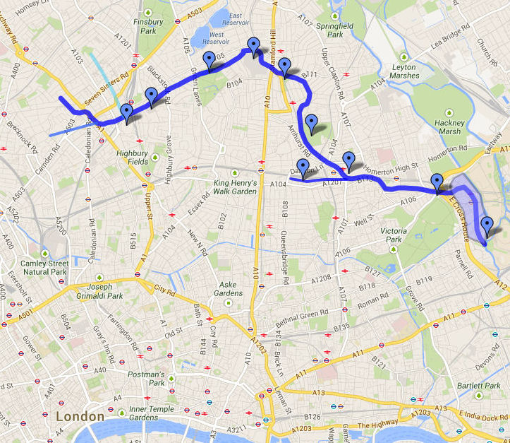
Walk: The Hackney Brook. Walk the path of the Hackney Brook from Finsbury Park to the River Lea, July 22nd 10:30-17:00 The Hackney Brook, culverted in 1860, runs through Stoke Newington along the north border of Clissold and Abney Parks. Tickets: eventbrite.co.uk/e/walk-the-hac…
‘Isaac Watt’s Mound’ in Abney Park Cemetery was on the bank of the Hackney Brook when it was simply Abney Park; the vast grounds of Abney House in the early-mid 18th century. Watts was a life-long houseguest of the Abney family.
@thelambpub @Gooner_AK @FieldsHighbury According to this pubology.co.uk/pubs/7195.html it was named the Sluice House Tavern after a different pub on the banks on the New River that was further north on the corner of present day Somerfield Rd/Wilberforce Rd. Was there a Hackney Brook S…
@thelambpub @Gooner_AK @FieldsHighbury According to this pubology.co.uk/pubs/7195.html it was named the Sluice House Tavern after a different pub on the banks on the New River that was further north on the corner of present day Somerfield Rd/Wilberforce Rd. Was there a Hackney Brook Sluice House there? Anyone has a map? https://t.co/FlRgyM3pIm
@thelambpub @Gooner_AK @FieldsHighbury Here’s the course of the Hackney Brook in that area. Bang on where the pub is, but it doesn’t mean there was a Sluice House there. It was culverted in 1860 so won’t appear in OS maps. May just have been named after the other pub that was de…
@thelambpub @Gooner_AK @FieldsHighbury Here’s the course of the Hackney Brook in that area. Bang on where the pub is, but it doesn’t mean there was a Sluice House there. It was culverted in 1860 so won’t appear in OS maps. May just have been named after the other pub that was demolished when the area was developed.