An aerial view of Clissold Park from 1905. Produced by local firm Aero Photo Co. of 54 Bouverie Road.
Back to themes
Aerial Photos
Photography and Visual Media
Aerial photographs, bird's-eye views, and images taken from above.
100 (<1%) posts currently match this theme.
Note: Theme classification is AI-enabled and imperfect, so some posts here will be misclassified and some relevant posts may be missing.
Filter posts within this theme by keyword, date range, image presence, or sort order.
Show theme trend over time Hide theme trend
Theme trend
Matches over time
Showing all years in this theme.
Showing first 100 posts…
An aerial photo of Clissold Park, showing the bandstand and Clissold House #125YearsOfClissoldPark
An aerial view of Clissold Park from 1905. Photo taken by local firm Aero Photo Co. of 54 Bouverie Road
1905 - Aerial view of Clissold Park by local firm Aero Photo Co. The bandstand was vandalised and removed in 1965.
This 1905 aerial photo of Clissold Park, shows the bandstand and footpath along BOTH sides of the New River
1907 - Aerial view of Clissold Park, Stoke Newington. The bandstand was vandalised and subsequently removed in 1965.
1907 - Aerial view of Clissold Park, Stoke Newington. Note the bandstand next to the house. It was removed in 1965.
Aerial view looking south down the A10 in SN; Originally a main Roman road called Ermine St en.wikipedia.org/wiki/Ermine_St… https://t.co/Wp1kYAxIFr
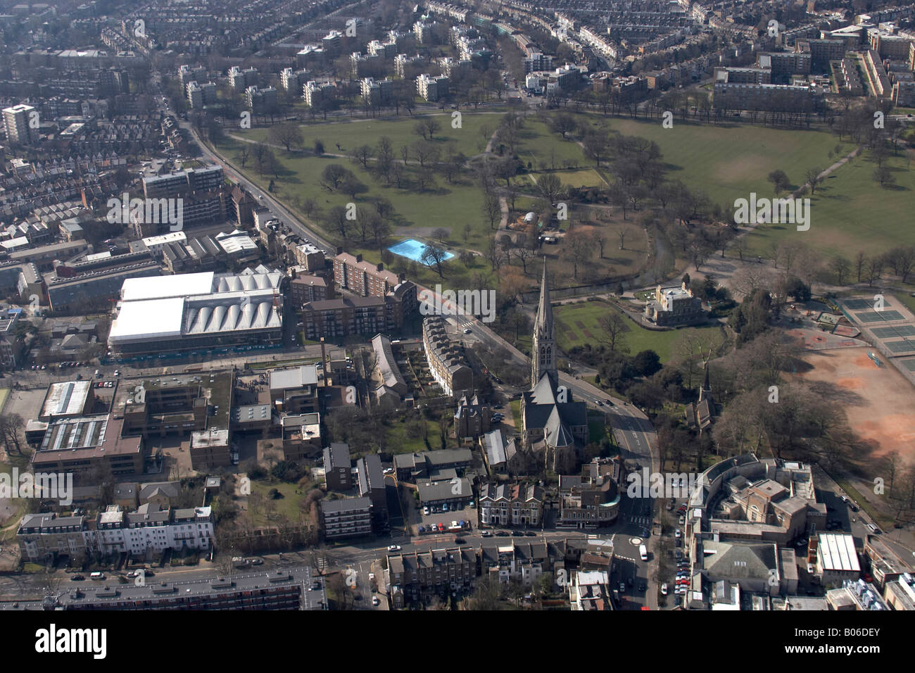
Aerial view of Clissold Park showing the playarea before it was redeveloped considerably a few years ago c8.alamy.com/comp/B06DEY/ae…
1905 - Aerial view of Clissold Park, Stoke Newington. The octagonal wooden bandstand burnt down in 1965.
1905 - Aerial photo of Clissold Park, showing the original deer enclosure was half the size of the current one.
This aerial photo shows Clissold Road before the school was built and also houses on Church St opposite the park which were demolished
1905 aerial view of Clissold Park. Note the deer enclosure was half the size it is today. There was a footpath along the river on both sides
Aerial view of Clissold Park. The bandstand was added in 1893, 4 years after the park opened. It was altered in 1912 and vandalised in 1965.
1949 aerial photo of Stoke Newington showing the severely damaged West Hackney Church on Stoke Newington Rd/Amhurst Rd. Rebuilt in the 60s.
1949 aerial photo of Stoke Newington showing the New River filter beds on Green Lanes which are now gone and the Clissold Park bandstand
1949 aerial photo of Stoke Newington showing the High Street and Church Street.
1949 aerial photo of south western Stoke Newington. Note the number of pubs on Howard Road.
Aerial view of north western Stoke Newington in 1952 showing the west Reservoir (left) and Filter Beds (right) on Green Lanes (middle)
1930 aerial view of north Stoke Newington, which included Manor House and bordered on Finsbury Park, the N4 portion of the old borough
1949 aerial view of Devonshire Square Church on SN Road/Walford Rd, which sustained severe damage during WW2 like others in the area.
1949 aerial view showing Abney Park Cemetery before it closed and nature took over, making it the nature reserve it is today.
1949 aerial view of the newly built blocks of flats on Albion Road, following severe bomb damage. Note houses on east side of Clissold Road
1949 aerial view showing Abney Congregational Church on Church Street opposite the cemetery, which sustained severe bomb damage.
Zoomable aerial view of Stoke Newington from 1949 britainfromabove.org.uk/en/image/EAW02…
1933 aerial view of the Allen Estate (Manor Road on the right and Bethune Road). The extensive gardens now form Allen Gardens.
1933 aerial view of the north eastern portion of Abney Park Cemetery, Listria Park and Manor Road. Note all the graves are clearly visible.
1933 aerial view of Green Lanes, Stoke Newington. The Victorian Green Lanes church can be seen towering on the left. Pulled down in 1968.
1949 vs. present aerial view of Howard Road and the surrounding area.
Then & Now: Aerial view of South-East Stoke Newington, which was completely transformed following housing development.
Here are Monica Blake’s presentation slides from yesterday detailing the untold story of the campaign to save the New River Reservoirs and Filter Beds in the late 1980s-early 1990s. It includes this great aerial photo of the now-gone Filter Beds. slideshare.net/HistoryofStoke… https://…
Here are Monica Blake’s presentation slides from yesterday detailing the untold story of the campaign to save the New River Reservoirs and Filter Beds in the late 1980s-early 1990s. It includes this great aerial photo of the now-gone Filter Beds. slideshare.net/HistoryofStoke… https://t.co/WMsSjCWlXI
@highamnews In an aerial photo from 1971 cars are parked in the middle of Petherton Road so the grass and pavement were a later addition.
Before nature reclaimed Abney Park: 1933 aerial view of the north eastern portion of Abney Park Cemetery, Listria Park and Manor Road. Note all the graves are clearly visible.
@clissoldpeople @CerayeSand @highamnews @_pasttense_ @drewerydyke The river in the park clearly starts in Green Lanes, where the Sluice House is, in an aerial photo from 1944, which unfortunately I cannot share online. In one from 1971 the course is identical to present one.
An amazing aerial view of Stoke Newington during the Stoke Newington Midsummer Festival c. 1995. Courtesy of Kay Trainor, the co-founder of the festival who’ll talk in the upcoming SN History Talks event about the 3-week annual arts festival, which took place during the 1990s.
1933 aerial view of Abney Park Cemetery and Manor Road, Stoke Newington.
1949 aerial view of Abney Park Cemetery, Stoke Newington
1930 aerial view of Woodberry Down, Stoke Newington
1952 aerial view of the Woodberry Down Estate, Stoke Newington
William Patten, the first Lord of the Manor of Stoke Newington, left his mark on the south aisle of St Mary's Old Church, which he had built as part of an extensive repair and extension of the parish church in 1563. (Ab alto = From Above)
1908 - Aerial view of Clissold Park, Stoke Newington.
1907 - Aerial view of Clissold House, Clissold Park, Stoke Newington. Originally named Paradise House, the house was built for local merchant Jonathan Hoare in 1790. The vast estate became a public park in 1889 following a 2-year campaign to save it from being built on.
@therobwells The photo was taken from Albion Road looking north. Bottom left in the aerial photo. You can see how Lilian Street connected the South and North section of Hawksley Road when it was U-shaped
@LynRennick @mbarnesn16 I did also wonder if it was taken by the paddling pool, where the aerial photo I shared with you from the early 70s show there was a patch
Aerial view of Woodberry Down in Stoke Newington before the development of the Woodberry Down Estate. Brownswood Tennis Club in the middle. 57 housing blocks were built by the London County Council in Woodberry Down between 1948-62 to house residents of slum clearance areas.
1971 aerial view of the streets that became Yorkshire Grove Estate in the 70s: Beatty Rd, Gunstor Rd, Nevill Rd, Orpen Rd, Victorian Rd, Victorian Grove, Walford Rd, Warwickshire Rd, Yorkshire Rd.
Aerial view of Abney Park Cemetery in 1933. It opened in 1840 as a nondenominational garden-cemetery. 200,000 people were buried in 60,000 graves over the years in the cemetery. The land was originally a private arboretum, Abney Park, which was planted in the early 18th century.
Aerial view of Stoke Newington Church Street in the 1990s during the annual ‘Stoke Newington Midsummer Festival’

Then & Now: Aerial view of Butterfield Green with: - LCC Bomb Damage Map - 1947 aerial view - Present day Compulsory Purchase Order was issued in the 70s for the houses where Butterfield Green was developed in stages during the late 70s and early 80s. (Thanks @mooney_photo)
@Laurenpett20 Here’s another aerial view of the estate
@MillarCaroline @WestReservoir @PeterKenyon @jonburkeUK @thameswater View from above in 1944
1931 - Fire in Price's timber yard, Stoke Newington Church St. This aerial photo shows Defoe Road before post-war development as well as Lordship Road before Denman House was built in 1937.
@Gooner_AK This aerial photo from 1944 shows as far as I can tell the area cleared, following bombing I’d imagine. The dark rectangle on the left is Emergency Water Supply container. So it would have been built possibly in the late 40s, early 50s at the latest perhaps.
Aerial view of Abney Park Cemetery in 1960. It opened as a nondenominational garden-cemetery in 1840 on the grounds of Abney Park, an 18th century arboretum behind Abney House mansion and the adjacent back garden of Fleetwood House mansion. 200K people are buried in 60K graves.
Aerial view of Clissold Park showing the long-gone octagonal bandstand next to Clissold House
Aerial view of Stoke Newington Church Street during the annual Midsummer Stoke Newington Festival in the 90s
Aerial view showing the former New River Waterworks in Stoke Newington. The 9 filter beds were drained and built over in the 1990s despite a lengthy local campaign, which saved the reservoirs that were also at risk of being lost after TW planned to sell the land for development.
@joeb_EY Here’s an aerial view from 1946 showing the New River in Aden Terrace. This section was drained not long after and the allotments opened.
1944 aerial view showing the 9 New River filter beds in Green Lanes opposite the Pumping Station. Drained and built over in the 90s despite a lengthy local campaign, which saved the reservoirs that were also at risk of being lost after TW planned to sell the land for development.
Bruce Oliver kindly shared with me photo his father took in 1969 of the site that was cleared in Lordship, Grayling and Yoakley Roads (seen in an aerial view from 1944) to make way for Grazebrook Primary School. The view looks south with Yoakley Rd on the left.
@KathyMWeston @VictorianLondon @BNArchive @AnneMPowers My pleasure. Here’s the photo I used in tbt animation and you can just about see Glebe Place behind the trees in this aerial photo.
@manaboutdogblog You can see it in this 1947 aerial photo. Doesn’t look like it was severely damaged or damaged at all. It wasn’t uncommon for buildings that were sound to be included in a development plan and they were pulled down.
Fascinating 1952 aerial photo showing the transformation of Woodberry Down from a leafy area with a large houses with big back gardens into an extensive estate with 57 housing blocks. The road with the old houses used to be part of connect to Lordship Road. It’s Newnton Close now
Aerial view of the Reservoirs and surrouding area in 1970. Lincoln Court in Bethune Road was built in 1969.
Terrific aerial view of Woodberry Down in north Stoke Newington in 1930 before the Woodberry Down Estate was built. There were only 80+ houses in this leafy part of Stoke Newington, most were grand. Cleared in late 1940s using CPOs. …tframe.historicenglandservices.org.uk/p/EPW031664/d4… via @HE_Archive
Aerial view in 1930 of Woodberry Down, Green Lanes, Manor House and Seven Sisters Road before post-war development and the development of the vast Woodberry Down Estate. …tframe.historicenglandservices.org.uk/p/EPW031661/ec… via @HE_Archive
@realnickperry @highamnews @HE_Archive I don’t I’d seen them like that in an aerial before or didn’t notice. Someone who works there now told me about underground filter beds that are still accessible (to an extent) so I didn’t expect to see them in an aerial photo.
@N16Breda @AbneyParkN16 Aerial view of Abney Park Cemetery in 1960.
Aerial view of Clissold Park in 1905. Note the east side of Clissold Road that was demolished in the 1960s to make way for a new secondary school. Also Glebe Place on the corner of Church St/Clissold Road where Manton House flats were built in the 1930s.
1933 aerial view of Manor Road, Abney Park Cemetery and Listria Park
1949 aerial view showing the newly built Hawksley Court Estate in Albion Rd, which was built on a built site. Prefabs on a pub site in Clissold Crescent/Carysfort Rd where council housing was built later. Clissold Road with the houses on the east side that were demolished c. 1968
@Microlambert @realnickperry @hackneywick Another aerial photo in the series taken from a kite that pretends to be an ‘Aëroplane’
1971 aerial view showing the original Victorian streets and many houses south of Allen Road that were pulled down for the development of Butterfield Green (yellow) and modern housing (blue).
Then & Now: Abney Park Cemetery from above c. 1950
1944 aerial view showing the 9 New River filter beds in Green Lanes opposite the Pumping Station. Drained and built over in the 90s despite a lengthy local campaign, which saved the reservoirs that were also at risk of being lost after TW planned to sell the land for development.
Aerial view of Stoke Newington during the Stoke Newington Midsummer Festival c. 1995. Courtesy of Kay Trainor, the co-founder of the annual festival.
Clissold Park from above, early 20th century
Aerial view of Abney Park Cemetery in 1933. It opened in 1840 as a nondenominational garden-cemetery. 200,000 people were buried in 60,000 graves over the years in the cemetery. The land was originally a private arboretum, Abney Park, which was planted in the early 18th century.
Aerial photo of Clissold Road in 1946, showing the houses and large back gardens on the east side where Stoke Newington School now stands. Built in the early 1850s, the houses were demolished in 1968 following compulsory purchase to make way for the school.
Aerial view of Abney Park Cemetery in 1933. It opened in 1840 as a nondenominational garden-cemetery. 200,000 people were buried in 60,000 graves over the years in the cemetery. The land was originally a private arboretum, Abney Park, which was planted in the early 18th century.
To illustrate the significance of the local campaign to save Clissold Park in 1886-8, I asked @RobertpHaslam to use AI to generate an aerial view of site, had the campaign failed and the land was built on. The campaign almost failed on several occasions. This could have happened.
Aerial view of the Stoke Newington Midsummer Festival. An annual arts and performance festival that ran from 1993 to 2003. A snippet of a talk Kay Trainor, one of the festival’s co-founders, gave at one of my events 5 years ago https://t.co/zoMXUBooJ8
Aerial view showing the 9 New River Victorian filter beds in Green Lanes. There was a lengthy campaign in the 80s and 90s to save the filter beds and reservoirs that were at risk of being built on. The campaign was successful in saving the reservoirs, but not the filter beds.
Abney Park Cemetery from above in 1946
1989 Aerial view of Whincop & Son’s timber yard in Stoke Newington Church St. One of the longest running businesses in the area, it opened in the mid 19th century. There was an entrance to yard from Summerhouse Rd. The area was redeveloped for housing (1-16 Wilmer Pl) in 2000.
Aerial view of Abney Park Cemetery in 1981, a few years after the Abney Park Cemetery Company, which managed and maintained it since 1840, stopped trading. (@AbneyParkN16 @treeruss)
1949 aerial view of Abney Park Cemetery (@AbneyParkN16 @treeruss)
WW2 allotments in Clissold Park as seen from above.
Abney Park Cemetery as seen from above in 1960. The nondenominational garden cemetery, which was opened in 1840 by the Abney Park Cemetery Company, became overgrown after the company ceased trading in the 1970s and the cemetery was no longer maintained. 200,000 people are buried…
Abney Park Cemetery as seen from above in 1960. The nondenominational garden cemetery, which was opened in 1840 by the Abney Park Cemetery Company, became overgrown after the company ceased trading in the 1970s and the cemetery was no longer maintained. 200,000 people are buried in 60,000 plots in the cemetery. The site was originally mainly an 18th-century private arboretum behind Abney House mansion.
RT @CaronLipman: Aerial photo of prefabs built after WW2 in Clissold Crescent, Stoke Newington - other local sites included Queen Elizabeth…
One of the two toilet buildings that used to be near Clissold House in the early 20th century, as seen in this aerial photo, was located where the play area is today.
The deer enclosure in Clissold Park was originally half the size of the current one. The overlay shows the 1913 map overlaid on today’s aerial view of the park. The deer enclosure at that time was only the area on the left marked ‘deer pen’. It opened in 1890, a year after the p…
The deer enclosure in Clissold Park was originally half the size of the current one. The overlay shows the 1913 map overlaid on today’s aerial view of the park. The deer enclosure at that time was only the area on the left marked ‘deer pen’. It opened in 1890, a year after the park opened, and was extended in the 1910s.
The deer enclosure in Clissold Park was originally smaller than the present day one. The overlay shows the 1913 map overlaid on today’s aerial view of the park. The deer enclosure at that time was only the area on the left marked ‘deer pen’. It opened in 1890, a year after the p…
The deer enclosure in Clissold Park was originally smaller than the present day one. The overlay shows the 1913 map overlaid on today’s aerial view of the park. The deer enclosure at that time was only the area on the left marked ‘deer pen’. It opened in 1890, a year after the park opened, and was extended in the 1910s.
In the early 20th century, the deer enclosure in Clissold Park was smaller than the present-day one. The overlay shows the 1913 map overlaid on today’s aerial view of the park. At that time, the deer enclosure was only the area on the left marked ‘deer pen’. It opened in 1890, a…
In the early 20th century, the deer enclosure in Clissold Park was smaller than the present-day one. The overlay shows the 1913 map overlaid on today’s aerial view of the park. At that time, the deer enclosure was only the area on the left marked ‘deer pen’. It opened in 1890, and the very first enclosure was even smaller—located across the footpath, opposite the present-day aviary.
The Open Space Plan in the 1943 County of London Plan included a proposal to expand Clissold Park and connect it with Abney Park as part of a “green corridor”, aiming to increase the amount of green public space in the area by linking existing parks, including Hackney Downs, Abn…
The Open Space Plan in the 1943 County of London Plan included a proposal to expand Clissold Park and connect it with Abney Park as part of a “green corridor”, aiming to increase the amount of green public space in the area by linking existing parks, including Hackney Downs, Abney Park Cemetery, Clissold Park, and Highbury Fields. I created a mock satellite view to give a rough idea of what a merger of Clissold Park and Abney Park might have looked like from above.
I created an overlay showing the plan of Daniel Defoe's estate in Stoke Newington Church Street, positioned over a present-day aerial view of the site. In addition to a large detached house and stables facing Church Street, where Defoe Road and the surrounding houses on Church S…
I created an overlay showing the plan of Daniel Defoe's estate in Stoke Newington Church Street, positioned over a present-day aerial view of the site. In addition to a large detached house and stables facing Church Street, where Defoe Road and the surrounding houses on Church Street are today (nos. 95–103), the estate included gardens and pleasure grounds that extended the entire length of present-day Defoe Road. Part of the original wall that surrounded the estate survives in two sections: one in the alleyway connecting Church Street and Oldfield Road, and another opposite Ayrsome Road. The section in the alleyway includes two bricked-up arches, possibly service or utility openings in the wall for the delivery of goods or the removal of manure from the adjacent stables.

Here's a short video snippet from my talk last week about using AI to provide new perspectives on Stoke Newington’s history, as part of Stoke Newington History Talks number 25, I presented, among others, images I created to illustrate the significance of the campaign to preserve…
Here's a short video snippet from my talk last week about using AI to provide new perspectives on Stoke Newington’s history, as part of Stoke Newington History Talks number 25, I presented, among others, images I created to illustrate the significance of the campaign to preserve Clissold Park for public use in the 1880s. The mock image offers a ‘what if’ aerial view to show the site of the park had the park been sold for housing development if the campaign failed or never happened. I feel that visualising such an alternate reality helps develop a deeper appreciation of the campaigners’ efforts and of what was at stake.
Here's a short video snippet from my talk last week about using AI to provide new perspectives on Stoke Newington’s history, as part of Stoke Newington History Talks number 25, I presented, among others, images I created to illustrate the significance of the campaign to preserve…
Here's a short video snippet from my talk last week about using AI to provide new perspectives on Stoke Newington’s history, as part of Stoke Newington History Talks number 25, I presented, among others, images I created to illustrate the significance of the campaign to preserve Clissold Park for public use in the 1880s. The mock image offers a ‘what if’ aerial view to show the site of the park had the park been sold for housing development if the campaign failed or never happened. I feel that visualising such an alternate reality helps develop a deeper appreciation of the campaigners’ efforts and of what was at stake. The full recording will be shared soon.
Here's a short video snippet from my talk last week about using AI to provide new perspectives on Stoke Newington’s history, as part of Stoke Newington History Talks number 25, where I presented, among others, images I created to illustrate the significance of the campaign to pr…
Here's a short video snippet from my talk last week about using AI to provide new perspectives on Stoke Newington’s history, as part of Stoke Newington History Talks number 25, where I presented, among others, images I created to illustrate the significance of the campaign to preserve Clissold Park for public use in the 1880s. The mock image offers a ‘what if’ aerial view to show the site of the park had the park been sold for housing development if the campaign failed or never happened. I feel that visualising such an alternate reality helps develop a deeper appreciation of the campaigners’ efforts and of what was at stake. The full recording will be shared soon.
Aerial view of the Stoke Newington Midsummer Festival. An annual arts and performance festival that ran from 1993 to 2003. A snippet of a talk Kay Trainor, one of the festival’s co-founders, gave at one of my events 5 years ago https://t.co/iYFWFLPaWN